Blog Index

Sunday, October 21, 2012

Hiwassee River Rail Adventure


We bought tickets to ride the train up the Hiwassee River Gorge to the Bald Mountain loop near Farner, Tennessee, in mid-October, 2012.  The trip begins at the restored L&N station in Etowah, Tennessee.  A museum, gift shop, ticket office and restrooms are located inside the depot.  Additional restrooms are located adjacent to the parking area.  


L & N Depot, Etowah, TN

Instead of boarding a train at the station, we boarded school buses for the seven mile trip to the Gee Creek Campground area of the Hiwassee Scenic River State Park.  Near a railroad crossing in the park, we walked past GMTX 2004, an EMD GP-38 locomotive, and boarded the four-car train.  The cars have all been restored and maintained by the Tennessee Valley Railroad Museum.  A small concession and gift shop is operated out of a former restroom lounge area in one of the cars.  Each car has at least one operable restroom.  There are no open cars on this excursion, but the rear vestibule on the last car was open with only a waist-high accordion-style gate across the passageway.  In addition, there were a couple of open dutch doors in the vestibules at the middle of the train.  These open areas provided an opportunity for photography without reflections from the windows.  


Bottom land along the Hiwassee River

Crossing the Hiwassee River


Bridge over the Hiwassee River

The tracks closely follow the river upstream

Apalachia power house and foot bridge

Beautiful fall colors across the foot bridge

Crossing Tennessee Highway 68

The loop begins as we pass under the trestle

Running the locomotive around the train at Farner, TN

Crossing the trestle to begin the loop on the return trip

Vivid fall colors on both sides of the gorge

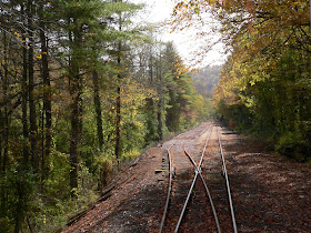
The second track opens up the forest "tunnel"

Fall colors explode along the track

Our return trip did not stop at Gee Creek, but continued another three miles to another passing siding where the locomotive again uncoupled from the train, switched tracks, ran past the train, switched tracks again, and recoupled to the other end of the train.  We then returned to Gee Creek where we boarded buses for the return trip to the depot.  The excursion we chose was just under four hours and cost $38 per person plus a $3 service charge per order.  The entire bus and train trip is non-smoking.

The excursion website is http://www.tvrail.com/hiwassee/index.php.  Several webpages are out of date, but the people answering the telephone are both friendly and knowledgeable.

Saturday, October 20, 2012

Cataloochee GSMNP


In mid-October, 2012, we visited another part of the Great Smoky Mountains National Park for the first time.  The Cataloochee valley is not as easily accessed as Oconaluftee, Clingmans Dome, Cades Cove or even Greenbrier.  Entrance into the valley requires driving up and down a mountain on a winding, narrow gravel road with no guardrails.  The easiest way to get to Cataloochee is to exit I-40 at exit 20 onto U.S. 276 in North Carolina.  Immediately turn right onto Cove Creek Road and follow it into the park.  The park service claims that the gravel portion of the road can be traversed in about 15 minutes, but that is completely dependent on the amount of traffic you meet and the traffic you follow.  With several blind curves and no pullouts for slower moving vehicles, it is definitely not the place to tailgate.  The road crests the mountain at 4071 feet Cove Creek Gap and then descends into Cataloochee Valley.  Part of the way down the mountain, the road is again paved and striped.  The only pullout is just beyond this point and affords spectacular views.


Looking toward Mt. Sterling from Cataloochee Overlook

Once in the valley, the road continues past a campground and a ranger station.  Beyond the ranger station, the road runs along a long open field.  Here we ran into a traffic jam similar to those found in Cades Cove.  A herd of elk were in the field as dusk approached.  Several park volunteers and rangers ensured that visitors did not approach the elk.  


Open field with elk


Young bull elk grazes

Posing for the cameras

A bull prepares to bugle

While Cataloochee is open year-round, most of the valley is closed from sunset to sunrise.  We will return to this part of the park again to explore further.

The park website is http://www.nps.gov/grsm/index.htm.

Thursday, October 18, 2012

Blue Ridge Parkway


In mid-October, 2012, we finally found an opportunity to drive along a portion of the Blue Ridge Parkway in mostly sunny conditions.  We entered the parkway near Asheville at MP 393.6 and drove south.  There are numerous overlooks along the route.  Below are some of my favorite views with their approximate mileposts and overlook names.

MP 399.8 Bad Fork Valley 

Mount Pisgah
MP 408.3 Unnamed Parking Circle

MP 409.3 View Funnel Top

MP 409.3 View Funnel Top

Mount Pisgah
MP 409.3 View Funnel Top

Side view of Looking Glass Rock
MP 413.2 Pounding Mill Overlook

MP 415.7 View Cherry Cove

MP 417.0 View Looking Glass Rock

Looking Glass Rock
MP 417.0 View Looking Glass Rock

MP 418.3 East Fork Overlook
(East Fork Pigeon River)

Second Falls of the Yellowstone Prong of the East Fork Pigeon River
MP 418.5 (roadside)

MP 421.5 (roadside)

MP 421.7 Fetterbush Overlook

MP 424.4 View Herrin Knob

We continued on the parkway to Richland Balsam Overlook (MP 431.4).  At 6,053 feet, this is the highest point on the Blue Ridge Parkway and it seemed the fall colors were past their peak.  Our afternoon journey on the parkway concluded at Balsam Gap (MP 443.1) and the intersection with U.S. 74/23, the Great Smoky Mountains Expressway.

The parkway website is http://www.nps.gov/blri/index.htm.

Tuesday, October 16, 2012

Great Smoky Mountains Railroad


When planning our early October, 2012 weekend trip to the North Carolina side of the Smokies, we decided to include a trip on the Great Smoky Mountains Railroad from downtown Bryson City, NC to the Nantahala Outdoor Center.  The weather forecast was for cool temperatures with overcast skies and a chance of rain.  In spite of this, we chose to ride on one of the open air cars.  These cars provide better views and allow for better photographs due to limited number of side posts and the arrangement of the bench seats.  These cars have been converted to have seats facing outward toward "picture window" openings in the side walls.  Very few of the people on our car chose to sit for any significant amount of time, but instead stood at the open windows watching the scenery.


View from open-air car Fontana

From the depot, the route heads southwest and crosses the Tuckasegee River within just a few blocks before a twisting climb out of the valley.  It follows U.S. 19 for about 1½ miles along a broad curve just outside town.  Where U.S. 19 merges with U.S. 74, the railroad veers off to follow Lower Alarka Road for about 2½ miles.  It then follows Grassy Branch Road to the shores of Fontana Lake.  


Bryson City Depot

Crossing the Tuckasegee River

After crossing the Little Tennessee River on a through-truss bridge, the line follows the western shoreline of the Nantahala River embayment of Fontana Lake.  Beneath the low hanging clouds of mid-morning, the lake surface was completely calm.


Confluence of the Nantahala River (right) with the Little
Tennessee River (ahead and left) on Fontana Lake

Glass-like reflections

Fog continued to shroud the mountains for most of the trip

More reflections along the Nantahala River section of Fontana Lake

Our train continues along the shore of Fontana Lake

Just above the transition from river to reservoir, the Nantahala Outdoor Center comes into view.  The excursion continues up the river another five miles to a quarry that has been in continuous operation since before the civil war.  Just past the quarry, U.S. 74/19 crosses to the west side of the river.  The train continues another mile to a passing siding where the engine is uncoupled from the south end of the train, runs around the train on the siding, and couples to the north end of the train.  The entire process to switch the locomotive from one end of the train to the other takes about fifteen minutes.  The train then returns down the river to the N.O.C. where passengers have an hour to eat and explore the area.  


Wesser Falls (Class VI rapids)

Top of Wesser Falls


A canoeing competitor navigates the first gate

Engine 1751 runs around the train


Nantahala Falls is really a Class III rapids


Once everyone is back aboard, the train returns to Bryson City.  The entire excursion lasts about 4½ hours.  Ticket prices for 2012 range from $49 to $92 depending on the level of service.  A season pass is also available.  Online food prices are not honored on the train, so planning ahead will save some money.


Autumn colors along the shoreline

A gentle breeze disturbs the stillness of the lake

Vibrant autumn colors on the hillside

Autumn colors along the tracks
The railroad website is http://www.gsmr.com/.
The outdoor center website is http://www.noc.com/.
The national forest website is http://www.fs.usda.gov/recarea/nfsnc/recarea/?recid=48634.