This trail is a pleasant walk from the Oconaluftee Visitor Center to the edge of Cherokee, NC. We walked to town and back on the first weekend in October, 2012. Since I took most of the pictures on the way back, I’ll narrate the walk from Cherokee upstream to the visitor center. The interpretive signs along the trail are written in both English and Cherokee and retell several of the ancient spiritual stories of the Cherokees. The text of the trailhead sign is as follows:
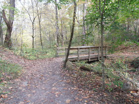
The trail begins at the end of the sidewalk on Tsali Boulevard (U.S. 441) and almost immediately heads into the woods. A sturdy footbridge has been constructed to cross the one drainage area encountered on the trail. The only road crossing is on a Bureau of Indian Affairs road that connects U.S. 441 with Big Cove Road on the other side of the river. The crosswalk is not well marked for motorists and it is near the intersection with U.S. 441, so caution is advised. The trail passes under the Blue Ridge Parkway as the parkway crosses the river. The turns away from the river at the Mountain Farm Museum and follows the fence along the edge of the meadow to the visitor center.The 1½ mile (one-way) trail follows the Oconaluftee River from the edge of the Qualla Boundary upstream to the Mountain Farm Museum and Oconaluftee Visitor Center in Great Smoky Mountains National Park.As you walk the river trail you will read about the Cherokees’ spiritual relationship with this place they call home. As long as they can remember, the Cherokees have nurtured living things. They have accepted the sacred responsibility of being caretakers of the earth, which provides everything needed for life.Great variations in mountain topography create an astounding diversity of plants, animals, soils, and climates in a relatively compact area. Great Smoky Mountains National Park protects the diversity of life sheltered within the mountain slopes that the Cherokees hold in great honor and respect.“The Great Smoky Mountains are a sanctuary for the Cherokee people. We have always believed the mountains and streams provide all that we need for survival. We hold these mountains sacred, believing that the Cherokee were chosen to take care of the mountains as the mountains take care of us.” – Jerry Wolfe, Cherokee elder
 |
| Oconaluftee River Trail |
 |
| Rattlesnake Mountain |
 |
| Footbridge |
 |
| Old Newfound Gap roadbed |
 |
| Early autumn color |
 |
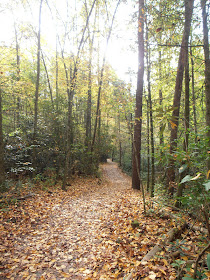
| Leaves on the trail |
 |
| The trail hugs the riverbank just south of the Blue Ridge Parkway |
 |
| The river converges after skirting an island just upstream of the Blue Ridge Parkway |
 |
| Calmer water beside the island |
 |
| A different type of fall color |
 |
| The river is seldom out of sight from the trail |
 |
| Meadow between the Blue Ridge Parkway and the Oconaluftee Visitor Center |
 |
| Mountain Farm Museum |
 |
| Oconaluftee Visitor Center |
Bicycles are allowed on this trail, although we didn't see any. Dogs are also allowed on leashes of six feet or less.
The park website is http://www.nps.gov/grsm/index.htm.

No comments:
Post a Comment