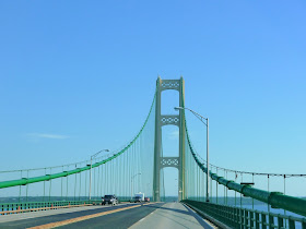
The Mackinac Bridge is a five mile route across the Straits of Mackinac that links the Upper and Lower Peninsulas of Michigan. The bridge was opened on November 1, 1957 and has a main span of 3,800 feet. The main span is the third longest in the United States, behind the Verrazano-Narrows Bridge (4,260 feet) in New York and the Golden Gate Bridge (4200 feet) in California. The length between cable bent piers is 7,400 feet while the overall length of the suspension bridge is 8,614 feet including the anchorages. The steel superstructure is 19,243 feet and the northern approach causeway is another 7,129 feet. The four lane bridge carries Interstate 75 and has a toll of $2 per axle for cars and $5 per axle for motorhomes and trucks. We crossed the bridge heading north to the Upper Peninsula in late July 2016.
 |
| Approaching the bridge |
 |
| On the southern deck truss approach |
 |
| Round Island and Lake Huron |
 |
| Still approaching the suspension bridge |
 |
| A metal grating road surface for the inside lane marks the beginning of the 7,400 foot suspension bridge |
 |
| Suspension cables include 42,000 miles of wire |
 |
| Passing under the south tower |
 |
| Approaching the middle of the span |
 |
| The roadway is nearly 200 feet above the lake at the middle of the span |
 |
| Nearing the north tower |
 |
| Passing under the north tower |
 |
| Nearing the northern end of the suspension bridge |
 |
| Star Line Hydro-Jet® Ferry on Lake Huron |
A toll of $4 per passenger vehicle and $5 per axle for motorhomes, buses and trucks is collected in both directions at a toll plaza at the northern end of the bridge in St. Ignace, Michigan.
The bridge website is http://www.mackinacbridge.org/.

No comments:
Post a Comment