Saturday, June 29, 2013

Natural Bridge - Pickett State Park


Pickett State Park has several geological features, including a natural bridge with a reported 86 foot span and 24 foot height.  During my visit to the park in late June, 2013, I stopped at the roadside parking area to view the bridge.  While the top of the natural bridge can be seen from the wood fence at the picnic area, its size can only be appreciated by taking a short walk to the bottom via a set of stone steps built into a seam in the rocks.


Parking area and picnic table


View of the bridge from the picnic area


Descending a few timber and stone steps leads
to this view across the top of the bridge


Closer inspection of the path across the bridge


View from the bottom

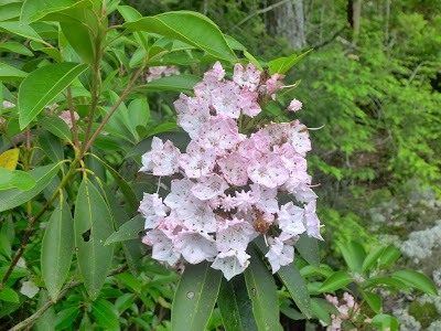
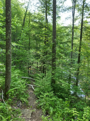
Before climbing the last few stone, timber and gravel steps to the parking area, I walked along the trail at the top of the bluff for about ¼ mile to stretch my legs a bit before driving home.


View from the top of the bluff


Rhododendron growing along the bluff 


A rock shelter has formed under the bluff

The park website is http://www.tn.gov/environment/parks/Pickett/.

Tuesday, June 25, 2013

Hidden Passage & Crystal Falls - Pickett State Park


During a short visit to Pickett Civilian Conservation Corps Memorial State Park in late June 2013, I chose to hike the Hidden Passage trail to Crystal Falls.  The round trip distance to the falls is about 1.6 miles, but the trail head is also the historical southern terminus of the 278 mile Sheltowee Trace.  
Sheltowee or Big Turtle was the name given to Daniel Boone by Chief Blackfish of the Shawnee.  This section is now a spur off of the main trail as the trace has been extended southward toward a possible future connection with the Cumberland Trail.  Crystal Falls is on an unnamed tributary of Thompson Creek and consists of two tiers of water curtains with a total height of 20 to 25 feet.


The parking area off TN 154 is well marked

The trail is well-maintained

The easy descent begins almost immediately

A sign marks the only trail intersection

The trail goes through a "Hidden Passage" in this rock shelter

Inside the Hidden Passage

Looking back at the Hidden Passage

Crystal Falls from the trail

Crystal Falls - a closer look


Crystal Falls from the base

Crystal Falls sparkles with the right shutter speed

On the return trip through the Hidden Passage, I recorded this hand-held video.  I then set it to play back at double speed to show the length of the passage without taking too much time.


The park website is http://www.tn.gov/environment/parks/Pickett/.

Monday, June 24, 2013

Piney River Trailhead - Cumberland Trail State Scenic Trail


While driving to the Stinging Fork Falls trail head, I noticed what appeared to be a roadside park on Shut In Gap Road.  Returning from my hike to the falls, I stopped to discover the Piney River trail head of the Cumberland Trail.  A quick bit of exploration provided a number of views of the river before it flows through Spring City and into the Watts Bar reservoir of the Tennessee River.  The Cumberland Trail is a work in progress that will eventually cross the state from Cumberland Gap in the north to the Tennessee River Gorge in the south as a continuous 300 mile foot path.

Piney River from the Shut In Gap Road bridge

Dry high water channel upstream of the bridge

On this day, the river was shallow and fast

Tree roots are exposed as the river scours the bank

The river cascades over the rocks


The valley widens below the bridge

Rocks impede the river's progress

Either over or around, water finds its way


This pool is deep enough to be the local swimming hole

The park website is http://www.tn.gov/environment/parks/CumberlandTrail/.
The Cumberland Trail Conference website is http://www.cumberlandtrail.org/.

Tuesday, June 18, 2013

Stinging Fork Falls State Natural Area


I hiked to Stinging Fork Falls in early June, 2013.  The round trip trail to the falls is about two miles.  There is also a spur trail to Indian Point that will add about ½ mile to the round trip distance.  The falls are located in a 783 acre natural area on Walden Ridge northwest of Spring City, Tennessee.  The large gravel parking area is about five miles up Shut In Gap Road from TN 68.  The falls consist of a plunge about 30 to 35 feet into a pool.  Above the falls is a long series of cascades as the creek follows the sloping cap rock toward the falls.

Parking area on Shut In Gap Road

The trail starts along the edge of a managed tree farm

Nothing posted at the trail kiosk

The trail finally enters the woods

Upon entering the woods, the trail narrows to a foot path

Mountain Laurel blooming along the trail

The double blaze signifies a trail junction

Indian Point

The view from Indian Point into the gulf is obscured by the foilage

Back on the main trail, now a foot path

Stairs assist with the descent into the gorge

More stairs to descend...and then ascend on the return

More Mountain Laurel blooms

There is a trail in here somewhere

Looking up slope toward a series of switchbacks

The open forest floor has been replaced with lots of ferns

Climbing over fallen trees is part of the adventure

More fallen trees and an obstructed view of the falls

Part of the cascade above the falls

The trail follows these rapids upstream to the falls

More rapids and a rock shelter below the falls


Fungi high rise

Looking downstream below the plunge pool

Stinging Fork Falls


Closeup of the falls

White blaze on the tree shows the trail

The trail skirts this rock house

Large boulder on the edge of the stream

Looks are deceiving as the trail turns right and heads up hill
instead of continuing downstream

Without the blazes, the trail blends into the boulder field

Some treads are missing on the stairs

An obstructed view of the cascade and falls

Another obstructed view of the cascade and falls

The rocky path leads to yet another set of stairs

There are some slick rocks to traverse on the lower part of this trail, so proper shoes or boots are imperative.  Also, walking or hiking sticks come in very handy in several of the switchbacks down to the falls.

The park website is http://www.tn.gov/environment/na/natareas/stinging/.