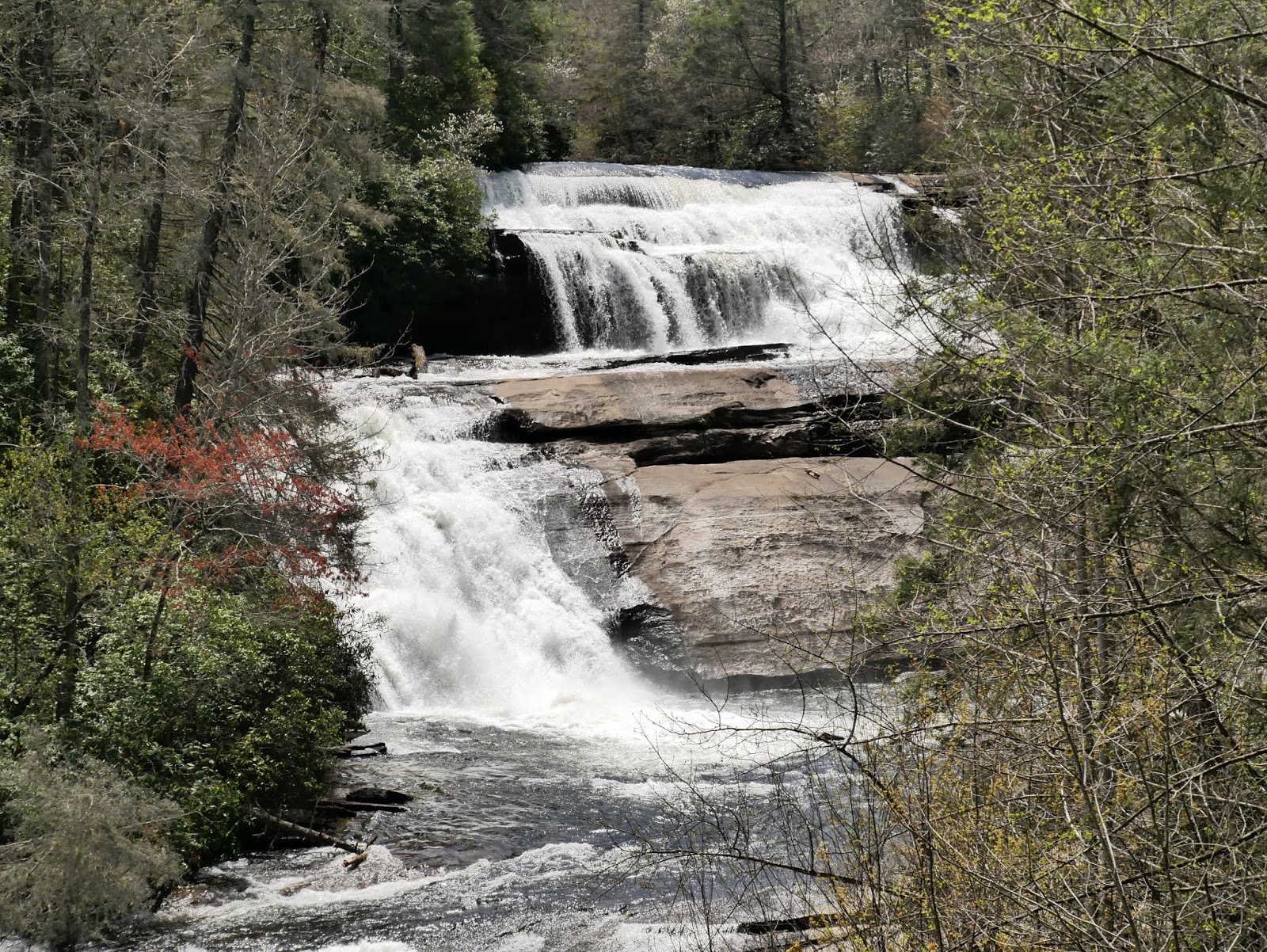
Our second hike of the day was to Triple Falls on the Little River in DuPont State Forest near Brevard during our April 2018 trip to western North Carolina.
To reach the designated parking area from the intersection of US 64, US 276, and NC 280 east of Brevard, drive east on US 64 for 3.7 miles. Turn right onto Crab Creek Road and drive 4.3 miles before turning right onto Dupont Road. Drive 3.1 miles on Dupont Road to the trailhead parking area on the right. Along the way, Dupont Road becomes Staton Road. Both parking areas are gravel surfaced and seem to drain well.
The upper, closer-to-the-trailhead parking area was closed on this visit for construction of a restroom building. This will be a huge improvement over the portable toilets. Depending on where you have to park in the lower lot, you may have to walk up to one-tenth of a mile to reach the trailhead kiosk. Two trails begin at the trailhead. The trail to Triple Falls and High Falls crosses Little River on a large pedestrian bridge before heading upstream and crossing under Staton Road. From the kiosk to the Triple Falls Overlook, the gravel trail is about 1/3 mile or 500 meters and climbs 120 feet or 35 meters.
If you would like a closer view of the waterfalls, continue up the trail an additional 165 feet or 50 meters to a wooden staircase on the left. Descending the 212 treads will lead to a large flat rock between the middle and lower tiers of the falls. There are several benches located at landings on the stairs for those who need to rest on the ascent back to the trail.
Our April 2018 trip to western North Carolina continued with a visit to DuPont State Forest. The first hike of the day was to Hooker Falls on Little River.
To reach the designated parking area from the intersection of US 64, US 276, and NC 280 east of Brevard, drive east on US 64 for 3.7 miles. Turn right onto Crab Creek Road and drive 4.3 miles before turning right onto Dupont Road. Drive 3.1 miles on Dupont Road to the trailhead parking area on the right. Along the way, Dupont Road becomes Staton Road. Both parking areas are gravel surfaced and seem to drain well.
The upper, closer-to-the-trailhead parking area was closed on this visit for construction of a restroom building. This will be a huge improvement over the portable toilets. Depending on where you have to park in the lower lot, you may have to walk up to one-tenth of a mile to reach the trailhead kiosk. Two trails begin at the trailhead. The trail to Triple Falls and High Falls crosses Little River on a large pedestrian bridge before heading upstream.
The trail to Hooker Falls stays on the right bank and heads downstream. While the river isn't always in sight, it is a constant audible companion to your left along the trail. The trail is well-maintained. gravel road for the first ¼ mile to the upper overlook. It is suitable for rugged strollers and possibly wheelchairs with an attendant pushing. Leashed dogs are also allowed on the trail. Beyond the upper overlook, the trail descends steeply on a hard rock surface that is not suitable for wheeled apparatus other than a motorized off-road utility vehicle. The trail ends at an engineered open expanse of flat rock that provides easy access to the river for swimming. The entire trail is about 0.3 miles long or the total round-trip walking distance from your vehicle is under 0.8 miles.
Since this is the most accessible waterfall in the forest, it is also the most crowded. If you are looking for solitude, your best chance is to go early in the morning on a weekday while school is in session. Even then, you likely won't have the trail to yourself.
I posted about my previous visit to Hooker Falls here.
Large lower parking area with portable toilets
Path from lower parking to trailhead
Trailhead kiosk
The trail follows the Little River downstream
Hooker Falls from the upper, accessible viewpoint
Hooker Falls from a lower vantage point
A closer view
One last look
Entry to DuPont State Recreational Forest is free.
We continued our April 2018 exploration of western North Carolina with a hike to Glen Falls. The falls are located west of Highlands, NC. To reach the trailhead from the intersection of US 64 and NC 28 in town, drive northwest on Main Street (US 64) for 0.4 miles and turn left onto Dillard Road (NC 106). Drive 1.8 miles on Dillard Road to the intersection with the paved Holt Road on the left and the gravel Glen Falls Road also on the left. A brown Forest Service sign was easily visible when we visited. Veer left onto Glen Falls Road and drive 1.1 miles to the parking area at the end of the road.
The trail is ¾ mile one-way with a descent of about 400 feet. It is well maintained with numerous timber steps. The East Fork Overflow Creek descends in several steps to create the series of falls named Glen Falls. The creek flows through Blue Valley before emptying into the Chattooga River and miles downstream into the Savannah River.
Topographic map with GPS route
Trail profile
A note about the name of the waterfalls:
The US Board on Geological Names, a part of the US Geological Survey, has determined the official name is Glen Falls. However, the US Forest Service adds a second 'n' to make Glenn Falls.
Forest Service misspelling
Trailhead kiosk
Two signed trailheads, the falls is to the left
Well maintained trail
Timber stairs
More stairs lead down to the first overlook
East Fork Overflow Creek
Another view from the first overlook
View upstream
View downstream
Looking back at the first overlook
There is a trail junction about ¼ mile from the trailhead. Turn right and walk a short distance to the second overlook near the top of the upper waterfall.
Trail junction
Another view of the junction
Side trail
Steps down to the second overlook
Brink of the 100-foot upper falls from the overlook
Blue Valley
Stairs back up to the main trail
Back on the main trail
Duck under or climb over?
Third overlook at the base of the upper falls
Sturdy railings allow safe viewing of the falls
View from the third overlook
Another view
Continuing down the trail...
...and around another switchback
One more switchback for good measure
More timber stairs
Lower falls at the fourth overlook
Another cascade just downstream of the overlook
Closeup of the base of the falls
Glen Falls
Entrance to Nantahala National Forest is free. The few areas that require a fee are well marked and usually worth it.