Monday, June 25, 2018

Laurel Falls Trail - Great Smoky Mountains National Park


We took time in early April 2018 to return to Laurel Falls on the Tennessee side of Great Smoky Mountains National Park. While spring rains had created a nice flow, it was not anywhere near the flow of my previous visit in December 2015. During that visit, Laurel Creek had so much water that the trail was impassable at the falls.

The 1.3 mile trail to the falls begins on the north side of Fighting Creek Road at Fighting Creek Gap. This is the high point on the route between Townsend and the Sugarlands Visitor Center. It is also just 1.1 miles northeast of Elkmont Road.

Although paved, the trail shows many signs of overuse and deferred maintenance. Unfortunately, it seems that there is no money to repair the trail. As this is one of the most popular trails in the park, it took some time to record images without many people. Don't expect to get these views of the falls without numerous people crossing in front of your view. Some people are totally oblivious to photo bombing your shot and some just came for the selfie, but there are still others that don't live in or near the mountains and are in awe of the waterfall. Hopefully, they all leave the park with less stress than when they arrived.

Overuse has widened the trail

Markers correspond to descriptions in the trail guide

Crumbling pavement

A social trail network along a ridge

Climbing off trail creates erosion

Blanket Mountain (4609' 3.4 miles)

An old rock slide

A trail side seep

Upper portion of Laurel Falls

Looking back at the footbridge over Laurel Creek between the upper and lower sections of the falls

View below from a trail side bench

Lower part of Laurel Falls with my wife sitting on the trail side bench


Top of the lower section

View of the lower falls from the trail

One more view from the bridge

Trail counter

Entrance to Great Smoky Mountains National Park is free.

The park website is https://www.nps.gov/grsm.

Tuesday, June 19, 2018

Painted Desert from Petrified Forest Park Road - Petrified Forest National Park


We continued our brief March 2018 visit to Petrified Forest National Park by completing the scenic drive along Petrified Forest Road. Once north of Interstate 40, the vistas are of the Painted Desert. The park has been enlarged numerous times to include most of the land that is visible from the overlooks along the road. The wayside exhibit for Lacey Point includes this quote from John Fletcher Lacey, a Congressman from Iowa:
There are other petrified forests, but this is The Petrified Forest of the World

Lacey Point


Wayside exhibit

View west toward Flat Top Butte, Rotten Bananas Butte, and Long Butte

Pintado Point

Pilot Rock

Pintado Point


Sidewalk to the point

Pilot Rock

Lithodendron Wash

Rain in the distance

View north of Lithodendron Wash and Black Forest

View northwest

Kachina Point


Painted Desert Inn

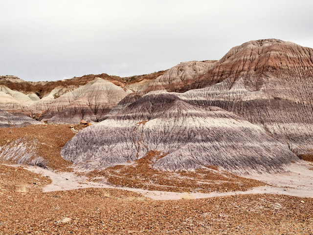
Painted Desert

Between Tawa Point and Tiponi Point


Parallel parking at the pullout

Red clay badlands

More badlands in the Painted Desert

Painted Desert

A closer look

A tributary of Lithodendron Wash

Tiponi Point


Wayside exhibits and viewing platform

Eroded red clay hills

Painted Desert

A closer view

Entrance to Petrified Forest National Park requires an entry fee of $20 per passenger vehicle for a 7-day pass. Any of the America the Beautiful passes may be used instead.

The park website is https://www.nps.gov/pefo.

Monday, June 18, 2018

Blue Mesa Trail - Petrified Forest National Park


On the homeward leg of our March 2018 trip to California, we took a short detour through Petrified Forest National Park. We exited Interstate 40 at Holbrook, Arizona and followed US 180 east about 20 miles to the southern entrance to the park. Since we had spent several days at the park in 2015, we just drove through the park from south to north along the 28 mile Petrified Forest Road with only a few stops. One of those stops was to hike the Blue Mesa Trail near the middle of the park. The paved, one-mile loop trail descends steeply from the top of Blue Mesa 120 feet to the base of the mesa. A sign at the beginning of the trail states that the grade is up to 35% on the descent and up to 18% on the loop at the base of the mesa. While the trail is five feet wide with no stairs and the pavement is in great condition, this is definitely not an ADA-compliant trail! A single bench has been provided about two-thirds of the way up the climb to the mesa top for those visitors needing to rest before continuing up to their vehicle. The very short trail to the picnic shelter is ADA-compliant and the view provided to the north showcases a great vista of the park.

Trail head

Picnic shelter

Crossing a gap in the mesa

View northwest from atop the mesa

View southwest to the trail 120' below

Trail begins a steep descent

Another view into the eroded mesa

Bench at trail switchback

Steep descent to the base of the mesa

Beginning of the loop

Blue Mesa

Petrified logs beside the trail

Layers of clay

Side "canyon"

People on the other side of the loop

Another side canyon

Overlook on Blue Mesa Scenic Road

Blue Mesa

Erosion around and below a petrified log

Conglomerate cap rock slows erosion

View southwest to the mouth of the "canyon"

Gravel from the conglomerate layer is scattered across the ground

More layers of clay and signs of erosion

Looking back across the floor at Blue Mesa

A geologist's paradise

Like debris from a woodlot

Evidence of flowing water

More layers beside the trail

Wayside exhibit provides the only sense of scale

A very clear delineation between clay layers

Another view of the trail

More petrified trees

A whole tree at the bottom of a ravine

Colorful minerals

Scattered piles of petrified wood

Depth of clay layers varies in a short distance

Colors seemingly change with the light

Beginning the climb back up

Note the stone retaining wall near the top of the ascent

View north to Pilot Rock (6234' 16 miles)

Erosion in the desert

Very deep-rooted shrub

View northeast from atop Blue Mesa

Entrance to Petrified Forest National Park requires an entry fee of $20 per passenger vehicle for a 7-day pass. Any of the America the Beautiful passes may be used instead.

The park website is https://www.nps.gov/pefo.