
According to geologists, Ritchie Ledges was once part of the shoreline of ancient Lake Erie. In the early 20th centurry, Hayward Kendall acquired property that includes Ritchie Ledges in order to create a country retreat for himself and his friends. His estate donated 430 acres around the Ledges along with a trust fund to the state of Ohio in 1929 with the stipulation that the "property should be perpetually used for park purposes." The state turned management of the park over to the Akron Metropolitan Park District in the early 1930s. The trails and shelters were built by the young men of CCC Company 567 between 1933 and 1942.

Considering the time of day, we decided to hike north to the trail intersection and then east to the loop trail near Ice Box Cave where we would hike counter-clockwise. Not really having any idea of what to expect, we hiked through the forest along the wide and nearly level gravel trail to the first intersection. An interpretive sign showed us that we were at the northeast corner of the large meadow and our route would head southeast and downhill. Heading down the trail, we came to a sign that warned us about the cliff edge. Since some of the gravel from the trail had washed out toward the cliff edge, on first glance it appeared that the trail headed over the edge, thus the need for the warning sign. This abrupt change from a gently sloping forest to 30 to 50 foot deep chasms was only one of the surprises we would find.
The connecting trail turned south at this point and ended at the Ledges Trail. We headed north toward the Ice Box Cave. There were warning signs on the park website and at the trail head kiosk that the cave was closed in an attempt to halt or at least slow the spread of a fungus that has killed millions of bats throughout the country.
 |
| View from atop the Ledges |
 |
| The Ledges Trail heads around the bottom of the ledges |
 |
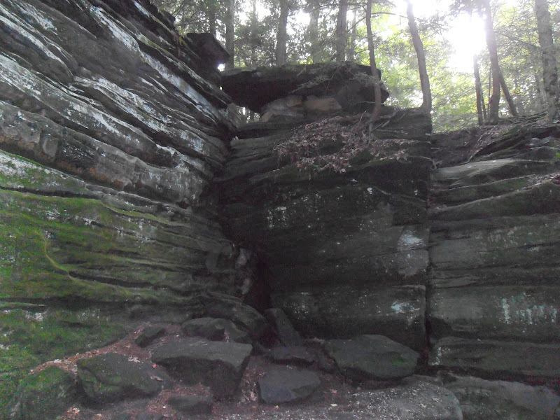
| Ice Box Cave is closed to the public |
Continuing north from the cave, the trail hugged the base of the ledges. The pictures don't adequately portray the scale of the ledges. CCC craftsmanship is visible in several areas, but mostly in the stone steps along the trail.
 |
| Using steps to gain six feet of elevation |
 |
| Two foot wide fracture between house-size rocks |
 |
| The ledges are composed of Sharon conglomerate |
 |
| Tree roots have woven around this series of rock steps |
 |
| Rock climbing is prohibited to protect delicate plant life |
 |
| Not all the fractures are vertical |
 |
| Fracturing continues |
 |
| How long before the upper rock slides off? |
 |
| CCC steps at the north end of the loop |
 |
| More CCC steps on the western side of the loop |
 |
| Exposed tree roots |
 |
| Weathered by wind and rain |
At the southern end of the loop, the trail quickly ascends the ledges. A side trail to the north leads to some picnic tables and an opening in the forest canopy. This location is simply called the Overlook.
 |
| View from the Overlook |
 |
| Nearing sunset from the Overlook |
While the Ledges Trail is only 1.8 miles, the additional hike from the parking lot to the trail head added another mile to our journey. We also hiked down to the Octagon parking area and back while on the western side of the Ledges Trail for a total hike of over 3.3 miles in just under two hours.
The park website is http://www.nps.gov/cuva/index.htm.
No comments:
Post a Comment