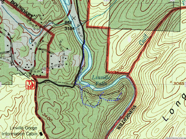
The trail system at Linville Falls consists of three trails. Each trail begins at the visitor center. The Plunge Basin Trail stays on the left bank of the river. It splits into two branches with the right branch leading to the Plunge Basin Overlook in 0.5 miles and the left branch descending into the Linville Gorge in 0.7 miles. Both branches of this trail are rated difficult.
The Erwin's View Trail crosses over to the right bank of the river and proceeds to four overlooks on a path rated moderate. The Upper Falls Overlook is 0.5 miles from the visitor center. The Chimney View overlook is 0.7 miles from the visitor center. The Gorge View overlook at 0.8 miles does not have a view of the falls. Erwin's View overlook is 0.9 miles from the visitor center. Stopping at each overlook results in a round-trip hike of 2.1 miles.
The third trail, Dugger's Creek, is a short ¼ mile loop on the east side of the parking lot. The trail is rated easy as it passes through old growth forest and rhododendron thickets as well as a small waterfall on Dugger's Creek.
As my time was limited, I chose to skip the Plunge Basin Trail and focus on Erwin's View and Dugger's Creek trails.
The Erwin's View Trail begins in the breezeway at the Linville Falls Visitor Center. After crossing from the left bank to the right bank on a substantial bridge, the paved surface transitions to a gravel lane. At 1/3 mile, a gravel trail from the Forest Service joins from the right. In another 500 feet, the trail down to the Upper Linville Falls Overlook departs on the left. This spur trail has numerous steps to aid in the descent.
While I was there in June 2017, a North Carolina Youth Conservation Corps (NCYCC) team of young adults was rebuilding the trail fence and some of the stone steps on the spur trail to the overlook. In just a week, they had already made significant progress in repairing the trail infrastructure. The overlook is a large rock slab with a stone and timber fence to keep visitors from venturing into the river.
The Linville River drops about 15 feet over the twin falls of Upper Falls. After dropping into a large pool, the river quickly swirls and drops into a small slot canyon as it disappears from sight. The topographic map and elevation profile detail the entire Erwin's View Trail and not just this first segment to the Upper Falls Overlook. The elevation on this first ½ mile segment rises and falls about 50 feet.
 |
| Topographic map with GPS route |
 |
| Elevation profile |
 |
| The trail crosses the river near the visitor center |
 |
| Linville River from the bridge |
 |
| Concrete resting bench |
 |
| Evidence of work on the main trail |
 |
| Part of an NCYCC crew rebuilding the side trail to the overlook |
 |
| Looking back at the only narrow point on the trail |
 |
| Looking back at the stone work from the overlook |
 |
| Upper Falls Overlook |
 |
| The twin falls of Upper Linville Falls |
 |
| Upper falls on the river's right |
 |
| Upper falls on the river's left |
 |
| Linville River leaving the upper pool |
 |
| Gathering speed |
 |
| Entering the slot canyon |
 |
| Descending out of sight |
Entry to the parkway is free.
The parkway website is https://www.nps.gov/blri.

No comments:
Post a Comment