
The Marine Railway trail follows parts of an old wagon road from US 441 to near Cabin 8 in the west section of Norris Dam State Park. The trail has two access points. The first is behind the deluxe cabins, but the main trail head for day use visitors is on US 441 about ¼ mile south (actual compass east southeast) of the park entrance. There is enough space at the trail head for three or four vehicles to be parked without blocking each other. I took this hike one evening after work in mid-May, 2013. There were no other vehicles at the pull out when I arrived, but an SUV pulled up as I as started out.
The trail consists of two loops with an adjoining segment as well as segments from the trail heads to the loops. I decided to hike the loops in a counter-clockwise manner. This kept me near the lake on the old roadbed for the first half of the hike. However, the second half of the hike required climbing and descending a ridge to the connector before climbing another hill back to my vehicle.
 |
| Trail head sign and map |
 |
| The trail segment to the first loop is wide and relatively flat |
 |
| Vegetation could quickly overtake the roadbed portion of the first loop |
 |
| The gentle descent has brought the trail down to the lake |
 |
| A spur trail to the right leads to a rest area |
 |
| High water has covered a portion of the rest area |
 |
| Driftwood has piled up on the shore of the rest area |
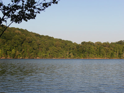 |
| The view across the lake from the rest area |
 |
| The main trail is wide enough for vehicles, but there is only enough foot traffic to keep one track open |
 |
| Openings in the forest allow views of the lake |
 |
| Wildflowers line the trail near the junction with the connector between the loops |
 |
| High water forces a detour |
 |
| The high water detour is a trail and not a road |
 |
| Back on the main connector trail, the route steepens and narrows under the power lines |
 |
| The connector trail opens up again in the woods |
 |
| Sign marks the junction with the 2.7 mile northern loop |
 |
| While the trail is still wide enough for vehicles, it has obviously been some time since one traversed this route |
 |
| A view of the Cove Creek embayment |
 |
| The first of two benches is at the start of a long climb up to the cabins |
 |
| The trail climbs about 250 feet up to the cabins |
 |
| The second bench is behind the cabins |
 |
| The trail descends back to the connector through the grasslands under the power lines |
 |
| A view of the return path of the southern loop from the northern loop |
 |
| Ferns grow along the path at the junction of the northern loop and the connector |
 |
| Back on the connector, a view of the hill climb to come |
 |
| So close, but still 250 feet to climb in less than 1000 feet of trail! |
Other than seeing the people in the SUV as I left the parking area, I only saw one other person on the hike and I saw him and his mountain bike three times. I met him under the power lines on the northern loop, then he passed me on the connector and I caught up to him as he was loading his bike at the trail head. He told me that he took the longer, more gradual path along the southern loop as the route under the power lines was way to steep to ride in either direction.
The park website is http://www.tn.gov/environment/parks/NorrisDam/.
No comments:
Post a Comment