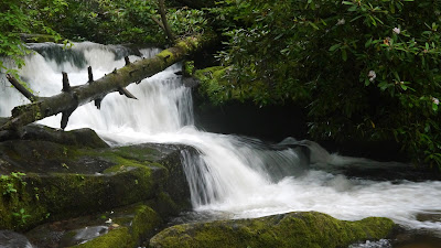
I made the long drive and short hike to Twentymile Creek Cascades in early July, 2013. The trail head is just off of NC 28 between US 129 and Fontana Dam at the Twenty Mile Ranger Station. There is a gravel parking area just beyond the station and maintenance buildings. This trek is more of a stroll in the woods than a hike as it follows an old roadway for the first ½ mile of the 0.6 mile distance. While the park service sign designates the location as "Twenty Mile", the NPS and US Geological Survey maps both designate the creek and region as "Twentymile." While there were a number of vehicles in the parking lot, I only met one individual on the trail.
 |
| Other than this one downed tree, the trail was in great shape |
 |
| Twentymile Creek is visible from the trail |
 |
| Mountain laurel was still blooming |
 |
| Another view of Twentymile Creek |
 |
| The bridge over Moore Springs Branch |
 |
| Moore Springs Branch from the trail bridge |
 |
| Turn right at the trail junction at the end of the bridge |
 |
| A short side trail leads to the cascades |
 |
| Twentymile Creek Cascades from the access trail |
 |
| Closeup of the upper section of the cascades |
 |
| The creek flow is high due to recent heavy rains |
 |
| The view downstream as the cascades continue |
The park website is http://www.nps.gov/grsm/index.htm.

videos wont work
ReplyDeleteSorry about that. It seems I now need to post videos to YouTube and then use them in the blog. I may get around to doing that some day or maybe not.
Delete