
One of the most popular trails in Death Valley National Park is the Golden Canyon Interpretive Trail. The trailhead is located just off Badwater Road two miles south of its junction with CA 190 in the Furnace Creek area. The parking area is paved, but is often completely full. We hiked the trail and explored a side canyon on our February 2015 trip to southern California. The one-mile long trail does not have a single path, but consists of the entire canyon floor. An interpretive brochure is available online that matches up with signed markers along the way. Unfortunately, we could only find markers 3, 6 and 10. Near marker 10 a sign marks the location of the Gower Gulch Loop that also returns to the paved trailhead. Continuing up the main canyon from marker 10 leads to the Red Cathedral. The park service has deemed this two-mile round-trip hike to be easy. I would agree except for the section beyond marker 10 where the trail goes under boulders and requires some rock scrambling in the area where an iron ladder used to exist. On our way to the Red Cathedral, we chose to explore a long side canyon to lengthen our hike to 4.4 miles. If you want more solitude, take the Gower Gulch Loop back to the parking area for a four mile hike.
 |
| Topographic map with GPS hiking route |
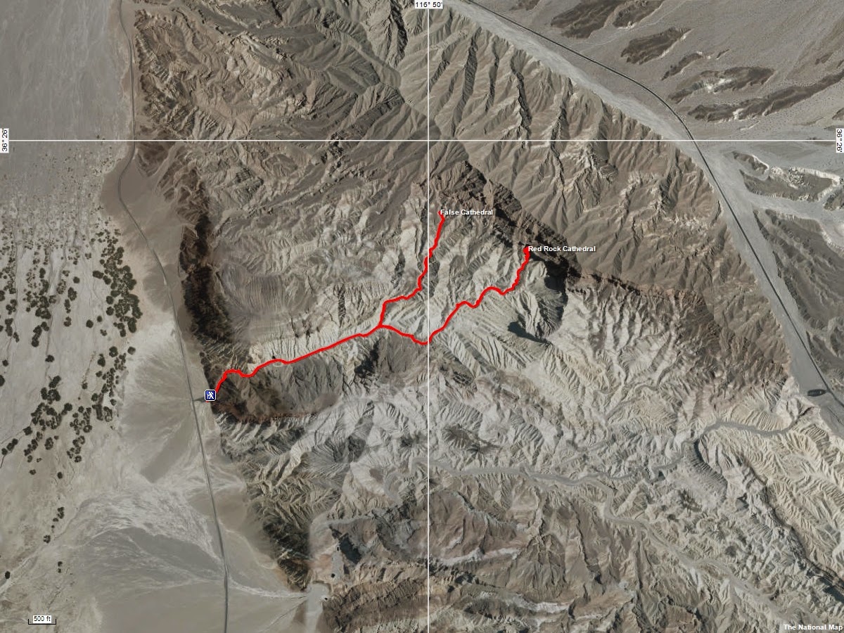 |
| USGS aerial photo with GPS hiking route overlay |
 |
| Paved parking area |
 |
| Looking across Middle Basin at the Panamint Mountains |
 |
| The Black Mountains have sedimentary origins |
 |
| Entering the canyon |
 |
| Asphalt remnant from old road washed out in 1976 |
 |
| More asphalt and multi-hued rocks |
 |
| Erosion channel in the canyon floor |
 |
| Looking back at the rock walls of the aptly named Golden Canyon |
 |
| Erosion has undercut rocks on both sides of the canyon |
 |
| Fantastically colored sedimentary rocks inclined at 45 degrees |
 |
| All of these features were created by flash floods |
 |
| Red rocks line part of the canyon |
 |
| Near vertical cliffs of golden mudstone |
 |
| The main trail follows this canyon to the right |
 |
| We chose to explore this canyon to the left |
 |
| Narrow slot canyons line the main canyon |
 |
| Some of the rock is a conglomerate that resembles concrete |
 |
| Golden and red rocks |
 |
| These three peaks remind us of the Patriarchs in Zion National Park |
 |
| Another side canyon leads to red rock spires |
 |
| The canyon widens out for a distance |
 |
| Heading in to the badlands |
 |
| Erosion has mixed the red and golden hues |
 |
| Even though this is a side canyon, someone left directions |
 |
| Beautiful end of the canyon, but not the Red Cathedral |
 |
| The Panamint Mountains were visible while hiking back down the side canyon |
 |
| Caltha-leaf Phacelia (Phacelia calthifolia) |
 |
| Gravel Ghost (Atrichoseris platyphylla) |
 |
| 480' peak south of the intersection of the two canyons |
 |
| Some of the rocks look like polished marble |
 |
| The sedimentary nature of the rocks is revealed again |
 |
| Looking back at the side canyon |
 |
| Another side canyon into the badlands |
 |
| Continuing on the main trail |
 |
| The trail weave between giant rock outcroppings |
 |
| More of the badlands |
 |
| Gower Gulch Loop trail |
 |
| Can you see the face in the hills? |
 |
| Rugged expanse of rock |
 |
| Nature's paint-by-numbers |
 |
| More of the golden mudstone lines the canyon floor |
 |
| Multi-colored hills |
 |
| Manly Beacon (800' elevation) |
 |
| Red Cathedral from a distance |
 |
| The trail goes under the fallen rocks |
 |
| The trail continues through the slot canyon |
 |
| Another climb through the narrow slot leads to the Red Cathedral |
 |
| The slot canyon opens up to reveal the Red Cathedral |
 |
| Part of the cathedral fell to the base long ago |
 |
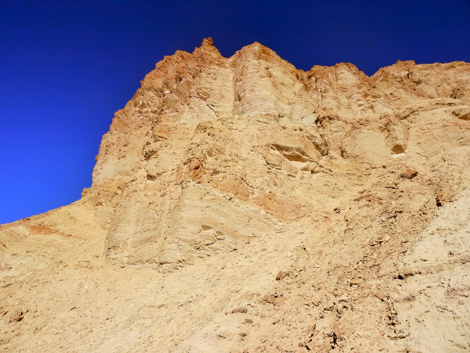
| Looking up the face of Red Cathedral |
An entrance fee of $20 admits all the passengers of a single vehicle for seven days. Other options include an annual Death Valley National Park Pass for $40, an Interagency Annual Pass providing access to most national park, national forest and BLM fee areas for $80 and a lifetime Interagency Senior Pass for those age 62 and older for $10.
The park website is http://www.nps.gov/deva/index.htm.
No comments:
Post a Comment