Thursday, July 9, 2020

Cataloochee - Great Smoky Mountains National Park


We completed our April 2018 visit to western North Carolina with a stop at Cataloochee in Great Smoky Mountains National Park. Just getting to Cataloochee can be an adventure for those not used to driving on twisting, hilly gravel roads. I've described the two ways into Cataloochee on a previous blog post here. We stopped at the Sal Patch Gap overlook, the only overlook along the route from US 276 into the valley.

Sal Patch Gap parking area

Paved trail to overlook

Signs of deferred maintenance

Ridge after ridge

Sal Patch Gap overlook

Spruce Mountain (5647' 6.5 miles) above the flank of Half Acre Ridge

Common serviceberry blooming (Amelanchier arborea)

Winding Stair Branch watershed

After leaving the overlook, we descended into the valley on the paved Cataloochee Entrance Road. Near the campground, we saw a group of elk on the edge of a field. Continuing on into the valley, the road reverts to gravel near Palmer Chapel. We crossed the field to the church in order to get a closer view of Palmer Creek. After crossing Palmer Creek on a sturdy bridge, the road follows Rough Fork for a short distance before terminating at the trailhead for both the Big Fork Ridge Trail and the Rough Fork Trail. We caught up to part of the elk herd in a large field near the end of the road.

Elk lazing and grazing

Sunning

Palmer Chapel from the road

Palmer Creek

Palmer Chapel from near the creek

Palmer Creek from the road bridge

Rough Fork

Caldwell Place

Caldwell barn

Field beside the Caldwell barn


Many elk have radio collars to allow rangers to track the herd

Entrance to Great Smoky Mountains National Park is free.

The park website is https://www.nps.gov/grsm.

Sunday, July 5, 2020

Dry Falls - Nantahala National Forest


Less than a mile west of Bridal Veil Falls is Dry Falls, our second stop of the day on our April 2018 visit to western North Carolina. The large, paved parking area is located on US 64 about 3 ½ miles west of downtown Highlands. 

The Civilian Conservation Corps (CCC) built a ½ mile trail in the 1930s that passes behind the falls and emerges on the other side of the Cullasaja River Gorge. The trail includes several sets of stone steps and has a concrete surface to the waterfall. Behind the falls and on the opposite side of the gorge, the trail surface is natural rock and packed gravel.

More recently, an accessible viewing platform was built immediately downstream of the parking area to allow visitors with mobility issues to view the waterfall.

Information board in the parking area

Solitary picnic table in the parking area

Vault toilet

Beginning of accessible path to overlook

Looking down on the CCC kiosk from the accessible walkway

Dry Falls from the accessible viewing platform

CCC kiosk

Looking back up the stone stairs to the CCC kiosk

Concrete trail surface

View from the trail

Switchback and more stairs

View of the falls from the switchback

View from the trail

Another view from the trail

Closer view

Cullasaja River Gorge below the falls

One more view

Almost behind the falls

View through the waterfall

Still in the mist zone

Closeup of Dry Falls from the opposite side of the gorge

A wider perspective

Fenced-in end of the trail


Entry to the parking area and falls is free.

The Nantahala National Forest website is https://www.fs.usda.gov/recarea/nfsnc/recarea/?recid=48634.

Wednesday, July 1, 2020

Bridal Veil Falls - Nantahala National Forest


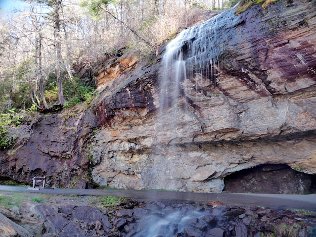
We continued our April 2018 trip to western North Carolina with an excursion further west from Brevard to the area around Highlands. Our first stop was at the roadside Bridal Veil Falls on US 64 about 2.7 miles west of downtown Highlands. An unnamed stream slides down a long cascade before freefalling about 40 feet according to Kevin Adams in his excellent reference work North Carolina Waterfalls - A Hiking and Photography Guide. The US Forest Service claims the waterfall is 120 feet, which likely includes the cascade above the falls. Almost immediately after passing over the original highway and under the current highway, the stream flows into the Cullasaja River.

When the road was originally built, designers routed it behind the waterfall as a tourist attraction. However, winter ice wreaked havoc on travel until 1959 when the current alignment eliminating the curve behind the falls was opened. Tourist travel behind the falls was still allowed for decades, but has been barricaded since 2003 when a large boulder fell onto the original roadway. 

Parking for several vehicles is provided at a gravel pullout adjacent to the falls.

Cascade and Bridal Veil Falls

A different view

Rock overhang

Crashing on the rocks

A final view

This roadside attraction is free to visit.

The Nantahala National Forest website is https://www.fs.usda.gov/main/nfsnc/home.

Saturday, June 27, 2020

Whitewater Falls - Nantahala National Forest


Our April 2018 trip to western North Carolina continued with a visit to Whitewater Falls on the Whitewater River. On a previous blog post, I provided information about how to get to the falls,  parking, accessibility, and fees. The only change to that information is that the fee has been raised from $2 per vehicle to $3. The paved trail is still steep for wheelchairs at a 4.75% grade and there are still over 150 stairsteps down to the viewing platform.

Paved path to overlook

Accessible view from the end of the trail

Upper third of the waterfall

Bench about halfway down the stairs

Most views from the viewing platform are partially obstructed

Upper third of the falls

Middle cascade

Lower third of the falls


Entry requires a fee of $3 per vehicle plus an additional $1 for each passenger over seven. Annual, Fourth Grade, Military, or Senior pass holders can enter their pass information on the fee envelope instead of paying the fee.

Tuesday, June 23, 2020

Looking Glass Falls - Pisgah National Forest


We continued our April 2018 visit to western North Carolina with a roadside stop at Looking Glass Falls. The waterfall is located near US 276 about 5.7 miles north of the intersection of US 64 and US 276. This intersection is in the community of Pisgah Forest just east of Brevard. Looking Glass Creek plunges about 60 feet just east of the highway to create the waterfall. Looking Glass Creek flows into the Davidson River less than ½ mile below the falls. The Davidson River empties into the French Broad River in Brevard. 

Limited parallel parking for about two dozen passenger vehicles is provided on the east side or uphill direction of the road. Due to limited visibility, turning around to head back toward Brevard from the parking area is not advised. However, a turnaround and additional parking are provided less than ½ mile up the road.

A set of concrete steps and ramps allow access to the creek below the falls.

Looking Glass Falls

View from the road

View from near the end of the ramp

View from the creek


Entrance to the forest is free.

The US Forest Service website is https://www.fs.usda.gov/nfsnc.

Friday, June 19, 2020

High Falls - DuPont State Recreational Forest


Our second hike of the day continued upstream from Triple Falls to High Falls on the Little River in DuPont State Forest near Brevard, North Carolina. This was during our April 2018 visit to western North Carolina. For more information about our short hikes in the DuPont Forest, view my posts from my previous visit to Bridal Veil Falls, High Falls, Triple Falls, Hooker Falls, and the Aleen Steinberg Center in 2017.

Trail sign

Little River above Triple Falls

Detail of High Falls

Base of High Falls


Entry to DuPont State Recreational Forest is free.

The friends of the forest website is http://www.dupontforest.com/.
The forest website is https://www.dupontstaterecreationalforest.com/.